
3D MODELING AND REPORTING MINERAL RESOURCES
Modeling is to reflect a mass or structure in nature, about which we can obtain data about its boundaries and quantity, in a 3D environment as close as possible to its reality. Working with these models from project acquisition to sales, from the beginning of the exploration process to the end of the mine operation process is no longer a privilege for our age, but a must. We offer on-site and remote solutions specific to your needs, especially for topics such as modeling, resource reporting, model control-review, all workflows required for modeling and team training.
Since your model is digitally positioned on a specific coordinate system, you can determine how many tons of ore of what quality you can obtain at any point in the model, if you wish. Therefore, with a simulation you can do before putting your exploration project into operation, you can decide whether it will cover your expenses and bring the profit margin you want.
You can make all your planning in the 3D environment, start the business with the method you want by using mapping and on-site marking tools (GPS, theodolite, etc.), budget your production for the term you want, and make comparisons and controls during production.
Gain insights and find answers in our latest articles listed below.
What else might you want to model besides your resource/reserve?
- Determine the grade and quality ratios of the elements or minerals you want in the ore bodies.
- Regional lithology boundaries,
- Mine production efficiency,
- Geometallurgical efficiency control,
- Ore body and surrounding faults and crush zones,
- Geotechnical, rock strength,
- Natural stone potential,
- Structural geology or geotechnical risks potential
are a few sample topics likely you can model.
The way you keep records of all studies and exploration activities, including your drilling logs and mapping in the field, is extremely important. Regularly taken drilling core photographs and drilling records (logs) free of unnecessary details… Keeping all records in a certain order from the beginning is of great benefit during modeling. The latest point reached by computer-aided design applications is now being able to obtain models that are very close to reality from numerical data in a few clicks. The reliability of the data you provide to the programs is very important; these records you keep retrospectively in the project you want to dispose of will constitute your greatest evidence at the time of sale.
The wireframing phase, which will constitute the ore mass, begins without distinguishing parallel masses at the time of logging; The most important step that requires well-founded experience about the mineralization type. This step needs to support the next steps with the clearest possible drilling photographs.

And many more interconnected steps… The execution of core drilling works says “I’m here again”.
Implicit orebody models created by 3D design programs are still considered insufficient for reporting by a certain segment of authority. As the “restless” software industry incorporates artificial intelligence, it is not far off that explicit (Explicit) modeling will be the main demand of the “resource reporting standards legislators” (CRIRSCO). For this reason, with reference to the previous steps, geological experience and obtaining refined data for the mass to be modeled are much more important.

It is important for a good prediction that the basis of geostatistical methods and, more importantly, that the origin of mineralization is well understood and that the origin of mineralization is based on concepts. Computer programs generally include “Ordinary Kriging” and IPD (IDW) interpolation methods embedded in them. In the Kriging method, determining the variogram in different spatial directions is again based on the geologist’s interpretation. In addition, if you know the origin of mineralization, you can include anisotropy in your geostatistical formulas in order to obtain values closest to those in nature. As a result, formulas and calculations aside, the importance of the mineralization concept that the earth scientist can put forward comes to the fore again. Regardless of your commodity (gold, copper, zinc, lead, chrome, etc.) and mineralization size, you can model it, adapt it for your mining and decision processes, and make the calculations you need.
Countries closely related to mining have determined the minimum standards for reporting mineral resources and reserves as well as exploration activities and turned them into laws, codes and regulations. Leading countries such as Australia with its JORC code, Canada with its NI 43-101 regulation, and others cooperate under the umbrella of international CRIRSCO. In addition to the fact that the code text of all member countries is almost the
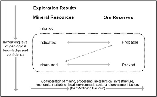
same in the draft, they define reporting standards in a common language by the intersection of transparency, materiality and competence.
The use of exploration and resource reports, which are very open to speculation and contain many chain issues, is a necessity, especially for companies that are listed on the stock exchange, to inform the public. However, although such reports, which are highly reliable, are respected, it is essential that an expert read the report to understand it. Not every accredited report may write only positive elements about mineralizations.
ATTENTION! If listing your company on the stock exchange is among your plans or if you already have a public offering, you may be subject to certain regulations in accordance with the relevant institutional regulation when it comes to public disclosure. As a guarantee that the data you provide is not misleading, the ways in which you obtain your data and the individuals and institutions reporting it may be required to meet certain standards. Based on the principles of “transparency, consistency of information and expertise”, your resources and production may need to be reported periodically by impartial experts who are subject to inspection and sanction and who are competent in their field. This reporting will require the signature of individuals competent in relevant fields who are registered with reputable organizations in multiple disciplines. Please note that the data calculated from your model will be used in the report under the resource and production subject headings, and that QA/QC compliance must be ensured in the entire mine production process, starting from the exploration stages, in order to create your ore model. In summary, the necessity of control and assurance standards will emerge in many chained earth sciences (Mining geology) steps to reach the final product report.
Even if you have nothing to do with the stock market or public offering, applying the controls and standards mentioned in the note above will have a positive impact on your mining investment and decisions. The data obtained and reports created with these standards are at the highest level of confidency in the market during the mining project purchase and sale stages.
Contact your investment advisor for all detailed information about your company’s public offering issues and requirements.
No matter your mining investment requirements, commodity (Au, Cu, Pb, Zn, Fe, Sb, etc.), or mineralization origin, don’t hesitate to reach out to us. Let us listen to your needs, craft a roadmap for your goals, develop a strategy, and execute it together.
Explore our website for insightful articles on mining and exploration, concise answers to frequently asked questions in the sector.
GMRTC Mineral Exploration & Modeling & Operation Consultancy
Istanbul - Izmir - TÜRKİYE
SITE MAP
CONTACT US
Before quoting or copying from our site, you can contact info@gmrtc.com
All elements (texts, comments, videos, images) on the GMRTC website (www.gmrtc.com) are the property of GMRTC unless otherwise stated, and are published to provide insights to interested investors, professionals, and students. Any detail that may arise during your process will affect the subject matter you are interested in on this website; therefore, GMRTC (www.gmrtc.com) is not liable for any damages incurred. It is recommended that you consult experts with all your data before making any decisions based on the information provided.