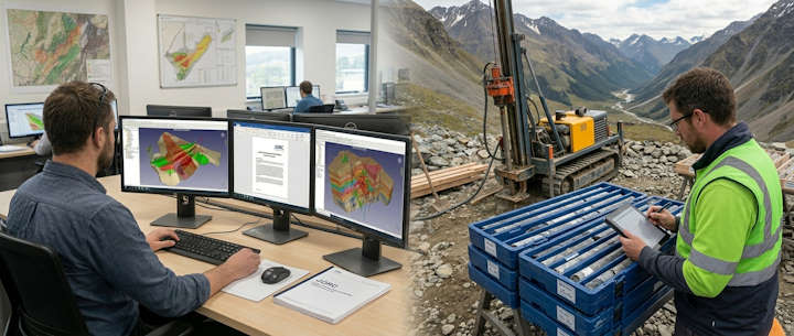
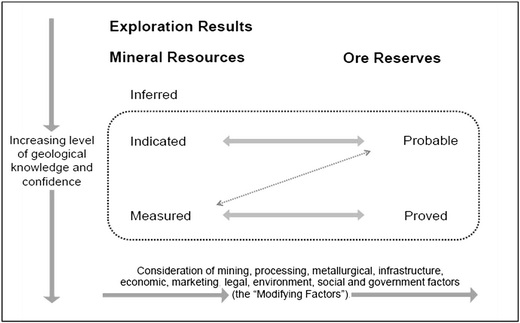
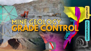
Using your drilling and sampling data, the subsurface mass is converted into a defined volume within a 3D digital environment. The boundaries of this volume form the wireframe (solid model); by filling this volume with rectangular prisms representing the rock, a block model is generated. By assigning data to each individual block, the model can be color-coded to visualize ore grade distribution and perform spatial calculations. By estimating the value of every block within the wireframe, the total resource quantity can be determined. These calculations can then be formally reported for investor disclosure and reporting purposes.
Since your model is digitally georeferenced within a specific coordinate system, you can determine the exact grade and tonnage available at any given point within the deposit.
By running simulations before bringing your exploration project into production, you can evaluate whether the operation will meet your financial targets and profit margins.
Your resource model is the fundamental starting point for all critical studies, including pre-feasibility, feasibility, pit and process design, and Life-of-Mine (LOM) planning.
By completing all planning in a 3D environment and utilizing mapping and surveying tools (GPS, total stations, etc.), you can implement underground or open-pit designs with precision, budget production over your desired timeframe, and conduct reconciliation and quality control during the production phase.
Additionally, you can develop models to forecast key parameters such as geotechnics, slope and tunnel stability, mineral processing, and metallurgy prior to active mining or feasibility assessments.
Modeling also allows for the calculation of resources and reserves for natural stone, marble, and industrial minerals, providing the most accurate estimations for quality and block values.
Detailed information on modeling and reporting can be found in our latest articles listed below.
By applying geostatistical methods to your drilling logs and sampling results, you can assign all numerical or alphanumeric data to the individual blocks within the 3D block model. This allows for the precise calculation of tonnage, grade, quality, Rock Quality Designation (RQD), and other quantitative or qualitative parameters. Using your reliably obtained drilling and sampling data, you can accurately estimate and determine:
The volume of any lithological mass (ore, waste, raw materials, natural stone, etc.),
Grade and quality ratios of specific elements or minerals within ore bodies,
Regional lithological boundaries,
Mining production efficiency,
Geometallurgical recovery and efficiency control,
The potential of ore bodies alongside surrounding faulting and shear zones,
Natural stone quality, fracture density, and block recovery potential,
Geotechnical properties and rock mass strength,
Structural geology and geotechnical risk potential,
and many other related datasets can be modeled to achieve your objectives by conducting high-fidelity estimations.
Reliable data translates to credible reporting. Maintaining quality control and adherence to standards during data generation in exploration activities requires strict discipline and meticulous attention to detail.
When you aim to develop a model for a mineralization identified within your license area or for a specific operational requirement:
The most up-to-date and accurate records of your drilling—specifically drill logs and the sample results recorded within them,
Systematic sampling data from the field, such as trench, pit, or channel sampling,
And a Digital Terrain Model (DTM) or as-built topographic survey of the surface, form the fundamental basis for modeling.
If production has occurred in the project’s history:
Bench and slope maps used in open-pit operations,
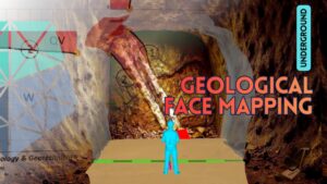
Underground face maps (geological face mapping),
Open-pit or underground grade control records,
As-built or offset maps of the mined-out sections,
If possible, in addition to these:
Core box photographs from the drilling programs,
The most recent surface geology, structural, and alteration maps of the site,
Colored surfaces or cross-sections generated from geophysical survey results,
Georeferenced structural, geometallurgical, or other operational data specific to your site,
In short, the more georeferenced data collected throughout all exploration activities are taken into account, the closer the resulting model will be to reality.
Considering all these points, establishing a database and reliably expanding this body of information in a multi-employee project requires a specific organizational culture. You must establish data acquisition criteria and Quality Control/Quality Assurance (QA/QC) protocols aligned with your initial corporate strategy and maintain them consistently. These protocols will determine the credibility level of the information you disclose or the reports you generate. If the protocols set at the beginning do not meet the criteria for the reliable data disclosure or reporting standards you require (such as JORC, UMREK, NI 43-101, etc.), you will face significant losses in both time and capital to rectify these deficiencies. Therefore, it is highly recommended to begin your exploration project by establishing a clear foundation aligned with your ultimate objectives.
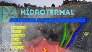
In the wireframe model you have constructed, the mechanisms of mineral deposition must be analyzed to determine the grade and quality values assigned to each individual block. By performing spatial analysis in the most compatible direction and function—and by selecting and applying appropriate geostatistical methods—the most high-fidelity model can be achieved. When the goal is to simulate reality, wireframing defines the boundaries, while geostatistics allows us to estimate the internal variability within those boundaries. This process enables us to make estimations regarding mineralization across areas spanning several square kilometers at various elevations, using drill cores only 5–10 cm in diameter.
A thorough understanding and conceptualization of the mineralization’s genesis are critical for accurate estimation. Most software packages include built-in interpolation methods such as Ordinary Kriging and Inverse Distance Weighting (IDW). In the Kriging method, determining the variogram across various spatial directions still relies heavily on the geologist’s interpretation. Furthermore, to obtain values that most closely reflect nature, you can incorporate anisotropy into your geostatistical formulas if you have a strong grasp of the mineralization’s origin. Ultimately, setting aside formulas and calculations, the mineralization concept established by the geologist forms the foundation of the entire process; geostatistics is the tool used to bring that concept closer to reality.
Comprehensive reports on mineral resources and mining projects are considered reliable when they are transparent, exhaustive, and authored by Competent Persons.
In the global mining industry, reports prepared in accordance with JORC or equivalent standards (such as UMREK, NI 43-101, PERC, etc.) are recognized as reliable, as they replace subjective interpretations with objective, data-driven evaluations. These reports must be signed by “Competent Persons” who meet the specific criteria established by the relevant national authorities.
The following are the most prevalent reporting standards consolidated under the CRIRSCO (Committee for Mineral Reserves International Reporting Standards) umbrella, which are largely harmonized with one another:
JORC (Australia): The pioneer of the system and the globally recognized “gold standard.” It serves as the primary reference point for transparency and competency in reporting.
NI 43-101 (Canada): Known as the most robust equivalent to JORC, this code is a legal requirement for mining companies listed on Canadian stock exchanges (TSX) and is noted for its stringent rules in technical audit processes.
UMREK (Turkey): Turkey’s local standard, fully integrated into the international system. Holding the same technical weight as JORC, it acts as an international passport required for Turkish mining projects to access global financing.
PERC (Europe): The reporting standard applicable in European markets and stock exchanges, harmonized with the continent’s legal framework.
SAMREC (South Africa): Representing a country with a deep-rooted mining history, this disciplined code specializes in the reporting of deep and complex deposits.
SME (USA): This U.S.-based standard ensures that mineral resources in the United States are reported in accordance with the expectations of the financial world and the SEC.
CBRR (Brazil): The CRIRSCO-aligned standard of Brazil, one of Latin America’s mining giants; it is of critical importance for iron ore and precious metal projects in the region.
KAZRC (Kazakhstan): A modern code representing Kazakhstan’s transition from the former Soviet system to international reporting standards in one of Central Asia’s key mining hubs.
MPIGM (Mongolia): A CRIRSCO-compliant reporting system developed by Mongolia—home to massive copper and coal resources—to attract foreign investment.
CHILEAN CODE (Chile): The mining reporting standard established by Chile, the world’s largest copper producer, in alignment with international investment standards.
NAEN (Russia): The reporting code that aligns Russia’s traditional reserve classification system with international CRIRSCO principles.
All codes within this structure utilize the same “Resource” and “Reserve” classification logic as JORC. Consequently, a UMREK report prepared for a mining site can be read by an investor in Australia or a bank in Canada with the same level of confidence as a JORC or NI 43-101 report. The difference lies not in the technical content, but rather in which country’s legal and financial regulations (or stock exchange) the report will be submitted to.
Even mining professionals occasionally find it challenging to interpret these highly technical reports. Therefore, it is recommended to seek expert consultancy when evaluating reports prior to making license acquisition or divestment decisions.
If your company is planning a stock exchange listing or is already publicly traded, you may be subject to specific regulations regarding public disclosure requirements. To ensure that the data you provide is not misleading, it may be necessary for both your data acquisition methods and the reporting individuals or institutions to meet established standards. Based on the principles of transparency, consistency of information, and technical expertise, your resources and production may need to be periodically reported by impartial, qualified experts subject to audit and enforcement. Such reporting will require the signature of “Competent Persons” who are registered with reputable professional organizations across multiple disciplines.
Please note that data calculated via your geological model under the headings of “Resource” and “Production” will be utilized in the report. To develop your ore model, minimum compliance with QA/QC (Quality Assurance/Quality Control) protocols must be maintained throughout the entire mining process, starting from the exploration phases. In summary, achieving the final report requires the implementation of control and assurance standards across a chain of multiple geoscientific steps.
Even if you have no immediate plans for an IPO or stock exchange listing, applying these audits and standards from the outset will positively impact your mining investments and strategic decisions. During the acquisition or sale of mining projects, the market credibility of data and reports generated under these standards is held in the highest regard.
For detailed information regarding your company’s public offering matters and requirements, please contact your investment advisor.
Stay up to date with all our mining and geology training programs by following our website and social media accounts.
For group training requests for your company staff within the scope of your projects or operations, feel free to contact us.
You can also reach out through our communication channels to request a quote for services tailored to your needs, including external auditing (exploration, production, modeling, reporting, and corporate mining), investment startup support, and ongoing consultancy.